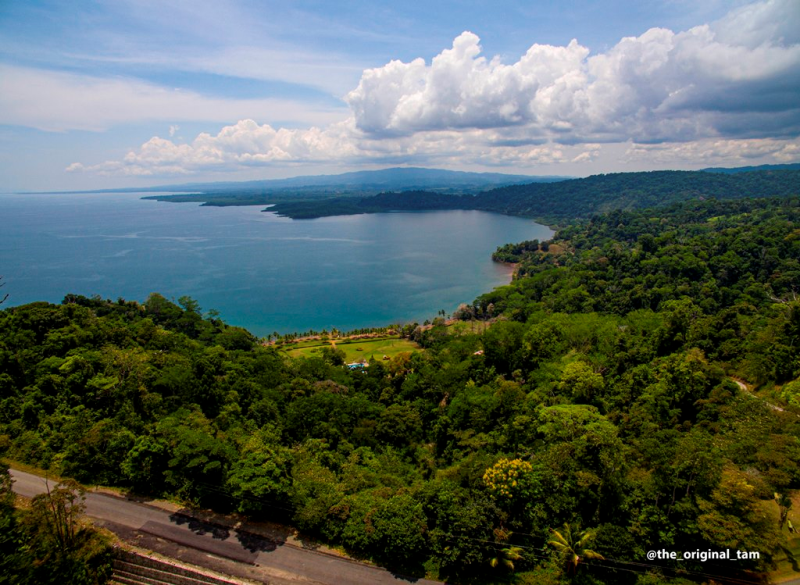
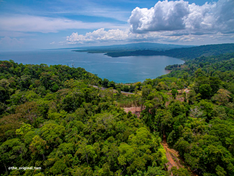
The Osa North region is where the best deals on rural real estate with big views can still be had. Osa North extends from Rincon in the north to Puerto Jimenez in the south and from the Golfo Dulce shoreline one the east to Corcovado National Park on the west.
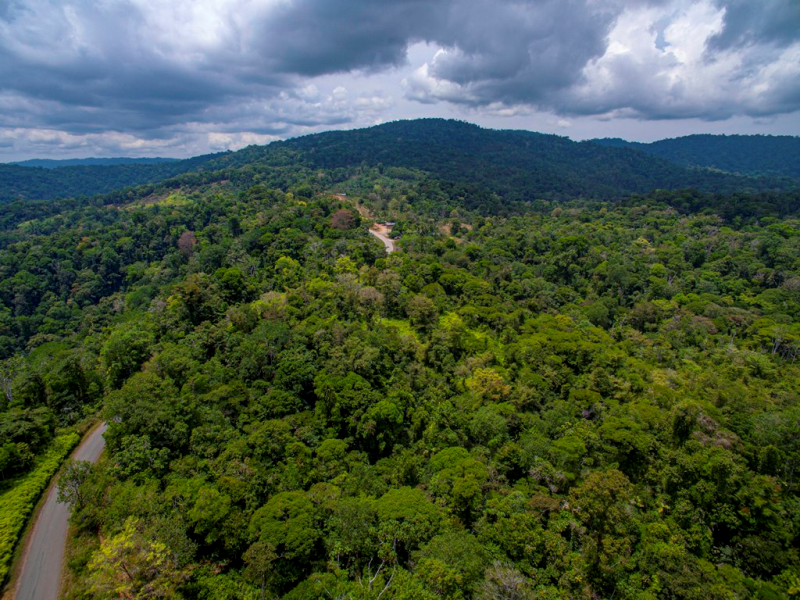
The main physiographic feature of Osa North is its coastal alluvial plane that rises gently from mangrove coast to inland terraces and foothills and then the ridges that rise to the peninsular cordillera. It is all along these ridgelines and terrace knolls and high points that magnificent gulf views rise above the lush green farmland of the lowlands.
Continued at the [bottom] of the page.
OSA NORTH
OSA NORTH
OSA NORTH
The Osa North region is where the best deals on rural real estate with big views can still be had. Osa North extends from Rincon in the north to Puerto Jimenez in the south and from the Golfo Dulce shoreline one the east to Corcovado National Park on the west.
The main physiographic feature of Osa North is its coastal alluvial plane that rises gently from mangrove coast to inland terraces and foothills and then the ridges that rise to the peninsular cordillera. It is all along these ridgelines and terrace knolls and high points that magnificent gulf views rise above the lush green farmland of the lowlands.
Continued at the [bottom] of the page.
Sandalo - |
Gallardo - |
Dos Brazos - |
Rio Tigre - |
Agujas - |
Monterey - |
Canaza - |
San Miguel |
Conte - |
La Palma - |
Playa Blanca - |
Puerto Escondido - |
Rincon - |
Sandalo - |
Gallardo - |
Dos Brazos - |
Rio Tigre - |
Agujas - |
Monterey - |
Canaza - |
San Miguel |
Conte - |
La Palma - |
Playa Blanca - |
Puerto Escondido - |
Rincon - |
Sandalo - |
Gallardo - |
Dos Brazos - |
Rio Tigre - |
Agujas - |
Monterey - |
Canaza - |
San Miguel |
Conte - |
La Palma - |
Playa Blanca - |
Puerto Escondido - |
Rincon - |
| Property ID | Property Name | Class | Area (Ha) | Price | Video |
|---|---|---|---|---|---|
| 2026020 | Ñeque - 0.4808 | Rural | 0.48 | $250,000.00 | |
| 2026019 | Ñeque - 0.4767 | Rural | 0.47 | $250,000.00 | |
| 2026018 | Ñeque - 0.519 | Rural | 0.51 | $250,000.00 | |
| 2026017 | Amapola - 0.199 | Rural | 0.19 | $80,000.00 | |
| 2026007 | La Cuna - 0.0319 | Rural | 0.0319 | $159,000.00 | |
| 2026002 | Bahia Chal - 6.27 | Rural | 6.27 | $377,000.00 | |
| 2026001 | Playa Blanca - 0.075 | Urban | 0.075 | $1,050,000.00 | |
| 2025076 | Agujas - 1.12 | Rural | 1.12 | $369,000.00 | See here |
| 2025073 | Rincon - 0.154 | Urban | 0.154 | $125,000.00 | |
| 2025070 | Guadalupe - 14.33 | Rural | 14.33 | $450,000.00 | |
| 2025069 | Palo Seco - 1 | Rural | 1 | $120,000.00 | |
| 2025058 | Barrigones - 0.9476 | Rural | 0.9476 | $80,000.00 | |
| 2025049 | Sandalo - 0.0696 | Urban | 0.0696 | $217,000.00 | |
| 2025045 | La Palma - 7.5 | Rural | 7.5 | $495,000.00 | |
| 2025044 | La Palma - 4.458 | Rural | 4.4588 | $595,000.00 | |
| 2025043 | El Tigre - 12.6 | Mountain Forest | 12.6 | $295,000.00 | |
| 2025042 | La Palma - 0.031 | Urban | 0.031 | $195,000.00 | |
| 2025040 | Juanito Mora - 4.4515 | Ocean Front | 4.4515 | $1,500,000.00 | |
| 2025037 | Playa Blanca - 0.25 | Urban | 0.25 | $250,000.00 | |
| 2025035 | Rio Nuevo - 267 | Mountain Forest | 267 | $495,000.00 | |
| 2025031 | La Cuna - 0.4589 | Rural | 0.4589 | $80,000.00 | |
| 2025030 | La Cuna - 0.5163 | Rural | 0.5163 | $90,000.00 | |
| 2025028 | Dos Brazos del Rio Tigre - 0.57 | Mountain Forest | 0.57 | $350,000.00 | See here |
| 2025021 | Monterey - 0.0759 | Urban | 0.07 | $95,000.00 | |
| 2025004 | Cañaza - 0.5 | Urban | 0.5 | $120,000.00 | See here |
| 2024098 | Monte Rey - 0.5 | Urban | 0.5 | $240,000.00 | |
| 2024095 | Barrigones - 1.4 | Rural | 1.4955 | $102,000.00 | |
| 2024075 | Agua Buena - 55 | Mountain Forest | 55 | $1,500,000.00 | |
| 2024070 | La Palma-Guadalupe | Pasture / Farm | 5.0963 | $200,000.00 | |
| 2024066 | Amapola - 10 | Pasture / Farm | 10 | $410,000.00 | |
| 2024051 | Cañaza - 0.22 | Rural | 0.255 | $65,000.00 | |
| 2024048 | Playa Blanca - 0.16 | Ocean View | 0.1643 | $349,000.00 | |
| 2024047 | Amapola - 0.24 | Rural | 0.2457 | $100,000.00 | |
| 2024046 | Cañaza - 2 | Rural | 2 | $125,000.00 | |
| 2024045 | Cañaza - 1 | Rural | 1.02 | $499,000.00 | See here |
| 2024040 | Cañaza - 0.095 | Urban | 0.095 | $25,000.00 | |
| 2024039 | Cañaza - 4 | Urban | 4 | $327,000.00 | |
| 2024038 | Amapola - 200 mts | Rural | 0.02 | $22,000.00 | |
| 2024037 | Cañaza - 1.6 | Rural | 1.66 | $200,000.00 | |
| 2024036 | Playa Blanca - 0.26 | Rural | 0.26 | $399,000.00 | See here |
| 2024035 | Sandalo - 9 | Pasture / Farm | 9.26 | $847,000.00 | See here |
| 2024004 | San Miguel - 20 | Mountain Forest | 20 | $800,000.00 | |
| 2024003 | San Miguel - 17 | Mountain Forest | 17 | $600,000.00 | See here |
| 2024002 | San Miguel - 17 | Mountain Forest | 17 | $495,000.00 | See here |
| 2023044 | Amapola - 0.0342 | Rural | 0.0342 | $150,000.00 | |
| 2023015 | Sandalo- 0.53 | Rural | 0.5306 | $250,000.00 | See here |
| 2023009 | Cañaza - 1 | Rural | 1 | $145,000.00 | See here |
| 2023008 | Cañaza - 1 | Rural | 1 | $195,000.00 | See here |
| 2023007 | Rincón - 55 | Mountain Forest | 55 | $2,950,000.00 | See here |
| 2023006 | San Juan - 358 | Mountain Forest | 358 | $2,500,000.00 | |
| 2023004 | San Miguel - 17.5 | Mountain Forest | 17.5 | $560,000.00 | See here |
| 2023001 | Amapola -10 | Mountain Forest | 10 | $390,000.00 | See here |
| 2022061 | Amapola -1 | Ocean View | 1 | $225,000.00 | See here |
| 2022058 | Ñeque -1 | Rural | 1.0436 | $200,000.00 | See here |
| 2022014 | San Juan - 45 | Mountain Forest | 45 | $215,000.00 | See here |
| 2022006 | Rincón - 80 | Mountain Forest | 80 | $700,000.00 | See here |
| 2021086 | Amapola - 3-6 | Flat | 3.6 | $180,000.00 | See here |
| 2021085 | Amapola - 37 | Pasture / Farm | 37 | $1,000,000.00 | See here |
| 2021071 | San Miguel - 3 | Mountain Forest | 3.8 | $114,000.00 | |
| 2021031 | Cañaza - 7577 | Mountain Forest | 0.7577 | $89,000.00 | |
| 2021017 | San Miguel - 4 | Mountain Forest | 4.6 | $150,000.00 | See here |
| 2021016 | San Miguel - 16 | Mountain Forest | 16 | $585,000.00 | See here |
| 2021007 | San Miguel - 2.25 | Mountain Forest | 2.25 | $180,000.00 | |
| 2019014 | Cañaza - 0.16 | Urban | 0.1607 | $65,000.00 | |
| 2019010 | Playa Agujas - 1.14 | Ocean View | 1.148 | $250,000.00 | |
| 2019006 | La Palma - 35 | Mountain Forest | 35 | $999,999.00 | |
| 2018037 | Palo Seco - 4 | Mountain Forest | 4.55 | $120,000.00 | |
| 2018017 | Cañaza - 33 | Mountain Forest | 33 | $450,000.00 | |
| 2018016 | Cañaza - 8758 | Mountain Forest | 0.87 | $85,000.00 | |
| 2018015 | Cañaza - 7370 | Mountain Forest | 0.737 | $75,000.00 | |
| 2018012 | Agujas - 3 | Mountain Forest | 3 | $225,000.00 | See here |
| 2018004 | San Miguel - 1 | Rural | 1 | $95,000.00 | |
| 2017004 | Sandalo - 25 | Rural | 25 | $4,128,425.00 | |
| 2016035 | San Miguel - 5000 | Rural | 0.5 | $100,000.00 | |
| 2016020 | Cañaza - 7370 | Rural | 0.737 | $140,000.00 | |
| 2016019 | Agujas - 5 | Mountain Forest | 5 | $150,000.00 | |
| 2014021 | Terrones - 5 | Mountain | 4.9 | $170,000.00 |
Across the Golfo Dulce the steep coastal mountains rise in dark green against a stairstep of higher mountains farther away, first a dusky blue range along the Amistad International Park boundary and thence to the lavender ribbon of the Talamanca Mountains beyond.
A large number of small rural farms populate the hills and mountains of Osa North and larger farms and ranches in the lowlands where rice, African palm, and cattle remain important to the regional economy though subordinate to the primary peninsular industry of ecotourism. Osa North is traversed by Highway 245 from Rincon, where it descends from the Mogos highlands all the way to the outskirts of Puerto Jimenez and the boundaries of its eponymous region.
The Golfo Dulce shoreline is mostly mangrove. Only in a few spots do beaches open up and have a bit of sand; mostly openings between the mangroves don’t have sand but small clay pebbles. As such the “beaches” are not classic swimming beaches and nowhere in this region is there a real surf and sand destination, though Playa Blanca outside of La Palma is the region’s beach attraction and draws big Sunday crowds.
This Osa North coastline is sheltered from direct Pacific Ocean activity by the geography of the gulf, so there is no wave action whatsoever along the Osa North coast, other than tiny little ripples lapping at mangrove roots. This makes this entire coastline a good target for nearshore moorings to anchor boats.
The maritime zone is administered mostly by the Municipality and only in a few places is the coast considered Natural Patrimony under MINAE’s jurisdiction. The portion of Osa North that lies south of the Rincon River falls within the Golfito Municipality. The part of Osa North that is north of the Rincon River is administered by the Osa Municipality.
A significant portion of the Osa North highlands are within the Golfo Dulce Forestry Reserve, which extends from the boundaries of Corcovado National Park.